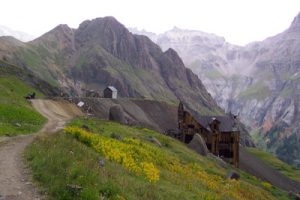
THE MOUNTAIN TOP MINE IN GOVERNOR BASIN, SEPTEMBER 2005, A PART OF THE CANYON CREEK WATERSHED BROWNFIELDS ASSESSMENT
Environmental Assessment of Mining Claims
Will Aid Land Acquisition
The Telluride Watch
Published: 9/08/06
By Christopher Pike
Within a 26-square-mile area that contains the Canyon Creek drainage basin, which includes the high-alpine basins of Yankee Boy, Governor and Imogene, lie scores of mining sites and with them the signs and impacts of their mining past, including waste rock and tailing piles, surrounded by countless dilapidated mining structures and portal openings.
It is the focus of an ongoing environmental assessment of 232 privately held mining claims dubbed the Canyon Creek Watershed Brownfields Assessment, and its results are being used by the Trust for Public Land and the U.S. Forest Service to acquire key mining claims in the high country between Ouray and Telluride, as part of the Red Mountain Project.
The Ouray County Commissioners, in partnership with the Red Mountain Task Force citizens group, TPL, and the Ridgway-based Trust for Land Restoration applied for and received a $200,000 grant from the US EPA in 2004 to conduct the three-year assessment. The county subsequently hired TLR to coordinate the assessment.
According to TLR Executive Director Pat Willits, “Brownfields” is a term coined by the EPA for its program of liability relief for perspective purchasers of contaminated land (or land that is suspected of being contaminated) to encourage cleanup and redevelopment. It started as a program in urban areas, and has been responsible for the revitalization of thousands of industrial sites and gas stations across the country. “In Ouray County, we successfully made the pitch to the EPA that abandoned mined lands are the historical Brownfields of the west, and that cleaning up some of the bad players was important for eco-system health,” Willits said.
“Canyon Creek was a great place to focus because we knew that there were several sites the Forest Service was interested in acquiring as part of the Red Mountain Project, yet they were nervous about the environmental condition of some of their sites. But we also knew that there were a few sites the Forest Service would never want to own, but that the community felt was important to preserve for its historical value, the prime example being Camp Bird Mine.”
When Phase I of the Canyon Creek Brownfields Assessment was completed in May, TPL acquired five claims comprising 56 acres and immediately transferred them to the U.S. Forest Service. Now the Forest Service is looking to acquire 13 additional claims, mostly in Yankee Boy Basin, south of Mt. Sneffles, totaling about 90 acres.
The Brownfields assessment is currently turning its attention to two more sites: Camp Bird Mine Level 14 (a collection of seven privately owned, patented mining claims totaling 75 acres) and two claims owned by Ouray County (as the result of tax-defaults in the 1930s) known as the Thistledown Mine. Level 14 today includes two intact, early 1900’s vintage Victorian-style buildings that housed and provided offices for the mine manager.
“We are really not sure what is going to come of our analysis of the Camp Bird and the Thistledown Mines” said Willits, adding, “I think of this next phase as a feasibility study. The people of Ouray County want to save sites that are historically interesting and important. The Forest Service sees some of these sites as potential liability traps.”
“Who should have to pay for cleaning them up? We are going to try and devise strategies that allow these sites to be saved, but not include any federal acquisition.”
The Camp Bird is the most famous mine in Ouray County, and perhaps one of the most famous mines in western lore. A crafty surveyor named Tom Walsh bought the claim for peanuts after the silver bust of 1893, when he literally kicked up gold-bearing ore that the miners hunting only for silver had cast aside. Walsh made millions, and avoided labor problems by paying top wages, and housing his men in an Imogene Basin boarding house run by the best cooks he could find. When Walsh cashed out, he built and donated to the City of Ouray the library building that today bears his name. His daughter, Evelyn, went on to become a Washington D.C. socialite and the owner, for many years, of the Hope Diamond.
The Red Mountain Project initially began in 1998 with a goal of acquiring from willing sellers 10,500 acres of historic landscapes and structures within and around the historic Red Mountain Mining District. Beginning in 2004, local entities including, the Red Mountain Task Force, the Trust for Public Lands, the Trust for Land Restoration and Ouray County officials have been directing their resources toward the Canyon Creek watershed region. The properties are located principally in the southern portion of the drainage basin with a few scattered along Canyon Creek, a tributary of the Uncompahgre River, in the eastern part of the drainage basin.
The objective of the Canyon Creek Brownfields Assessment is to prioritize properties for additional study that best meet the Brownfields Grant redevelopment and land revitalization goals of this project. A Phase I ESA was conducted in 2005 and reported earlier this year to assist in determining whether any immediate actions on the subject claims are necessary to comply with existing environmental laws and regulations, but subsurface conditions were not studied to ascertain soil contamination, waste replacement or ground water conditions.
On May 16, a public meeting was held to provide a progress report and obtain community input, and answer questions related to the assessment.
That report was compiled on April 14, 2006, and a report to the Ouray BOCC was accepted and signed on May 8, narrowing down to 2,204.63 acres when adjusted for claim overlap. Properties ranged from “free of contamination and liability concerns” to “contaminated water discharges and/or ground water contamination concerns which likely require active or passive treatment.” According to Willits, the project participants are looking for sites with water quality problems with “strict liability so as to not get caught up in the rules.”
“We need to identify those sites to avoid the forest service having to clean up any sites,” said Willits.
Access to the area is via Camp Bird Road (County Road 361) by crossing the Uncompahgre River and by following Canyon Creek for 1/4 mile to the project boundary. The eastern side of the Sneffels mining district along Imogene Creek is sometimes divided into the Camp Bird and Imogene Basin mining district.
Camp Bird Mine is owned by Federal Resource Corporation of Salt Lake City, as part of their holdings totaling about 1,700 acres in the Canyon Creek drainage. The corporation has a clean-up plan for Camp Bird Level 14 that has been approved by the Colorado Division of Minerals and Geology.
“Federal Resource has been candid, cooperative and forthcoming with us. They say they will finish their cleanup obligations at Level 14 when they get the capital to do so. We’d like to have some ideas in place before that as to how the public can help save the site for its historical and scenic value,” said Willits.
Placer gold was first discovered in the San Juan Mountains in 1860 and the first claims were staked in the Canyon Creek areas in the 1870s. The claims that would eventually lead to the discovery of the most famous mine in the drainage basin, the Camp Bird Mine, were staked in 1877, which operated from 1896-1978 and then from 1986-1990. It was the second largest producer of gold and silver in Colorado with a total estimated production of 1.5 million troy ounces of gold and 4 million troy ounces of silver.

LEVEL 14, CAMP BIRD MINE
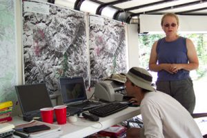
GEOLOGISTS ROGER MELICK AND DORINDA BAIR AT WORK IN THE CANYON CREEK BROWNFIELDS ASSESSMENT FIELD LAB ASSEMBLED FOR THE SUMMER 2005 CANYON CREEK PHASE I ENVIRONMENTAL ASSESSMENT
Participants in this project include the Trust for Land Restoration, based in Ridgway. TLR is a Colorado land trust that combines land restoration with legal expertise “to achieve the goal of restoring and conserving environmentally significant lands degraded by human activity.” It is tasked with overseeing the work of the environmental consultant, and coordinate stakeholder involvement, facilitate public outreach, make landowner contacts, secure access, engage regulators and legal implications of the evaluation. The role of TLR is to coordinate activities with the USFS and to conduct the environmental liability management tasks of the Canyon Creek drainage basin site assessment Brownfields Project, in reference to 36 prioritized claims that are being considered for Red Mountain Project acquisition.
An important element of this proposed assessment will be environmental liability management performed by TLR, according to the Brownfield’s goals and objectives. The Brownfields assessment is intended to help prioritize private properties in the Canyon Creek watershed for public acquisition. On behalf of the Red Mountain Project, Trust for Public Land has, to date, received authorization to utilize federal Land and Water Conservation Funds (LWCF) totaling $14.2 million to acquire private property in the Red Mountain, Ouray and Telluride Mining Districts and convey them to the U.S. Forest Service.